North-west · Navagio and the North-West
Navagio Beach — Shipwreck Beach
Also called Shipwreck Beach, Smugglers Cove, and — historically — Agios Georgios cove
Last checked
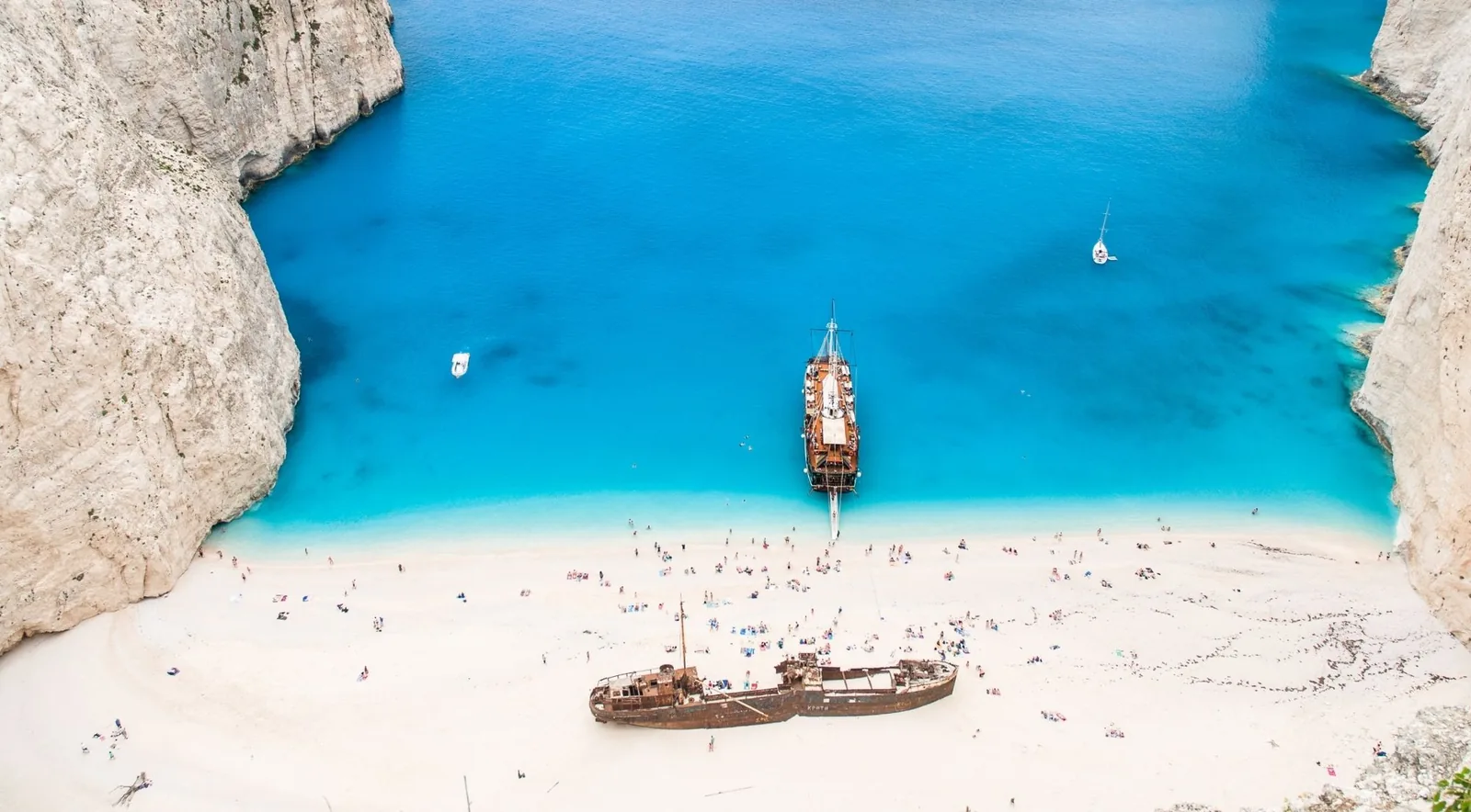
The most photographed cove in Greece, and the only beach on the island closed by an annually renewed ministerial decision because the cliffs above it are failing. What is left is a viewpoint, a boat trip that circles the bay, and a rusting hull that is now the subject of a €3.9 million rescue plan.
At a glance
- Surface
- gravel
- Access
- Level 5 of 5
- Parking
- Not applicable
- Sunbeds
- NO
- Taverna
- NO
- Toilets
- NO
- Lifeguard
- No
- Blue Flag 2026
- No
- Step-free access
- No
- Marine Park
- Outside the park
- Greek name
- Ναυάγιο
- Coordinates
- 37.85955, 20.62494
Official figures: Closed - 50 m exclusion zone for vessels and swimmers and no landing anywhere on the shoreline, renewed annually since 2023
The cove
Navagio is a pocket cove on the north-west coast, enclosed on three sides by sheer white limestone and open only to the north-west. It is about 193 metres of shoreline at the foot of cliffs that run to roughly 200 metres.
The surface is the first thing most visitors get wrong. It is not sand. It is bright white limestone pebbles and gravel with some coarse grit — and that is a direct consequence of the island’s geology rather than an accident. The western half of Zakynthos is hard, fractured Upper Cretaceous limestone. It fails as rockfall rather than eroding grain by grain, so it supplies almost no sediment to its own beaches. The state’s own 2026 tender for the shoreline works confirms the point from the other direction: the material specified is gravel.
The colour of the water is the same rock at work. Pale limestone reflects light back up through the water column, which is why the bay reads as an improbable turquoise in photographs taken from 200 metres above it.
The wreck
The ship is the Panagiotis, and it ran aground in October 1980. Beyond the month and year the record is genuinely disputed, and this site does not pick a day.
What is measurable is its condition. An XRF analysis puts the hull at 60.22% iron, and it now sits roughly 25 metres from the water — close enough that wave action during winter storms is the stated reason for the rescue plan. Conservation of the hull cannot begin until the shoreline in front of it has been rebuilt.
The viewpoint above the bay
Since vehicle access was closed outright in September 2024, the clifftop platform is the only way to see the cove from land, and it has become a destination of its own — sitting at about 219 metres, at 37.86184, 20.62562.
It is worth knowing what that involves. The access road is still legally a forest road; cars get stuck on it daily, and in June 2026 the president of the Volimes community warned publicly that “we will mourn victims on this road”. There are no toilets at the platform. On Red Code fire-risk days the access closes entirely, with a €300 fine for entering — the first such ban of summer 2026 fell on 13 August.
The municipality’s safety response followed two incidents in the same week of May 2026: a 22-year-old American slipped roughly 10 metres down the cliff while trying to reach the flagpole and had to be recovered by the fire service, a mountain-rescue unit, a Port Authority boat and civil protection; three days later a woman attempted to jump from the platform. Since then the site has had its first guard post, daily security staffing, full fencing at the flag, and barriers on the access and escape roads.
Photographing it
The cove faces north-west, computed from the coastline geometry. That matters more than it sounds: the midsummer sunset azimuth of about 301° falls squarely into the cove’s opening, so June is when the sun actually sets into the frame from the viewpoint. By October the sun has swung to about 260° and the alignment is gone.
Morning light is flatter but the platform is quieter, and the wind on this coast roughly doubles between breakfast and six in the evening.
Getting there by boat
Boats circle the bay; none of them lands. The shortest crossing is from Porto Vromi at 4.22 km. From Agios Nikolaos in the north it is 13.66 km, because the route has to round Cape Skinari — which is also why the Blue Caves are the opposite calculation, at 0.43 nautical miles from Agios Nikolaos against 6.49 from Porto Vromi.
One caution that costs people their trip: Porto Vromi is two separate coves, 265 m apart across the water but 16.2 km and 23 minutes apart by road, served by two different mountain roads. Check which one your operator departs from before you set off.
Nearby beaches
Ordered by measured driving time, not by distance along the shore — on this island the two rarely agree.
- Navagio viewpoint 15 min The clifftop platform — since 2023, the only way to see the cove from land.
- Porto Vromi 23 min The nearest boats. Two coves share the name and they are 23 minutes apart by road.
- Porto Limnionas 45 min The nearest place on this coast where you can actually get into the water.
- Makris Gialos 55 min If the point of the day was snorkelling rather than the wreck.
Choose somewhere else if…
- You wanted to swim on the west coast. Navagio is closed to swimmers. The nearest real swimming on this coast is Porto Limnionas →
- You wanted the photograph. The famous shot is taken from above, not from the sand — the viewpoint →
Navagio Beach: common questions
About the cove itself. For what is permitted this season, see the status page.
No — it is bright white limestone pebbles and gravel. That is geology, not opinion: the west coast is hard fractured limestone that fails as rockfall and supplies almost no sand. The state's own 2026 tender specifies gravel.
The Panagiotis, which ran aground in October 1980. The exact day is disputed across sources, so this site gives the month and year only. An XRF analysis puts the hull at 60.22% iron.
No. There is no path down, and the beach is closed in any case. Vehicle access to the clifftop viewpoint was closed outright in September 2024; the platform is reached on foot, and its road is still legally a forest road.
On the cliff above the bay at roughly 37.86184, 20.62562, about 219 m up. It has a guard post and fencing as of June 2026, and no toilets.
Usually Porto Vromi, which is the shortest crossing at 4.22 km. Be careful: Porto Vromi is two coves — 265 m apart across the water, but 23 minutes apart by road on two different mountain roads. Confirm which one your operator uses.
The cove faces north-west, so the midsummer sun sets into its opening — around 301° in June. By October the sunset has swung to about 260° and no longer lines up. Mornings are flatter but calmer: the wind here roughly doubles between breakfast and 6pm.
Still have questions? Email us at info@zakynthosbeaches.com
What we could not establish
- The exact date of the grounding. Accounts disagree on the day. The month and year are secure: October 1980. Contemporary Greek press; Ta Nea of 6 October 1980 p.16 is one contemporaneous record.
- Whether the 2023 twenty-minute limit on time in the bay still stands. The Harbour Master's decision of 12 June 2023 imposed one alongside the 50 m distance. Its renewal for 2026 is unconfirmed. The Port Authority.
Sources
- OpenStreetMap beach node, retrieved 28 August 2026 — 37.85955, 20.62494. Greek Wikipedia's landmark coordinate sits about 200 m south and should not be used for the sand.
- FEK B' 3033/28.05.2026 and its three predecessors, 2023–2025.
- Kathimerini, 9 July 2026, on the shoreline-nourishment plan; tender published 8 July 2026.
- Kordouli et al. 2024, cliff monitoring at Navagio, Remote Sensing 16(23):4610.
Where it is
Navagio (Shipwreck Beach) sits on the northwest coast, in the Navagio and the North-West cluster. Open it on the map to see what else is within a short drive.
Getting to the water
Boat trips around the island
Some of the best-known places on Zakynthos have no road to them — Navagio, the Blue Caves, Marathonisi. A boat is not an upgrade to those; it is the only way in.